

As global energy demands surge and environmental concerns intensify, renewable energy sources have emerged as the cornerstone of sustainable development and energy independence. Solar, wind, and hydroelectric power represent the most viable and commercially proven renewable technologies, offering organizations unprecedented opportunities to reduce operational costs while meeting ambitious sustainability goals. These clean energy solutions have demonstrated remarkable cost reductions over the past decade, with solar panel efficiency increasing by 40% and wind turbine capacity factors reaching record highs. For decision-makers evaluating renewable energy options, understanding the distinct advantages and applications of each resource is crucial for making informed investments that align with both financial objectives and environmental responsibilities. This analysis explores the three primary renewable energy sources, their assessment tools, and practical implementation strategies that drive successful sustainable energy transitions.
Solar Power Assessment Tools
Solar Potential Analysis
Modern solar potential analysis tools have revolutionized the way organizations evaluate their solar energy opportunities. These sophisticated platforms combine satellite imagery, 3D modeling, and advanced algorithms to provide accurate assessments of solar installation potential.
Industry-standard software solutions like Aurora, Helioscope, and PVsyst analyze multiple factors including roof geometry, shading patterns, and historical weather data. These tools generate detailed reports on expected energy production, optimal panel placement, and potential cost savings.
For example, a recent analysis for a manufacturing facility in Arizona revealed that their 50,000-square-foot roof space could generate approximately 1.2 million kWh annually, covering 75% of their electricity needs. The assessment included factors such as HVAC equipment placement, structural load capacity, and seasonal sun patterns.
Key metrics evaluated during solar potential analysis include:
– Total usable roof area
– Annual solar irradiance
– Shading impact assessment
– Structural integrity evaluation
– Energy production estimates
– Financial projections and ROI
Advanced features now include augmented reality visualization, allowing stakeholders to see virtual panel layouts overlaid on their actual property. Machine learning algorithms continuously improve prediction accuracy by incorporating real-world performance data from existing installations.
Many utilities and local governments offer free preliminary assessments using publicly available tools, helping organizations make informed decisions about solar investment potential.

ROI Calculators
ROI calculators serve as essential tools for evaluating the financial viability of renewable energy investments. These sophisticated instruments help stakeholders assess potential returns and achieve lower energy bills through accurate cost-benefit analysis.
Modern ROI calculators incorporate multiple variables, including installation costs, energy production estimates, local utility rates, and available incentives. For solar investments, these calculators typically consider factors such as panel efficiency, geographic location, roof orientation, and shading patterns to generate precise financial projections.
Key metrics provided by these calculators include:
• Payback period
• Net Present Value (NPV)
• Internal Rate of Return (IRR)
• Annual energy savings
• Carbon offset calculations
Many leading manufacturers and solar providers offer customized calculators that account for regional specifics, such as local solar incentives, feed-in tariffs, and maintenance costs. These tools often integrate real-time data and historical performance metrics from similar installations to ensure accuracy.
For maximum benefit, users should input detailed information about their current energy consumption patterns, property specifications, and available budget. This data-driven approach enables decision-makers to make informed choices about renewable energy investments while understanding the long-term financial implications of their decisions.
Wind Energy Evaluation Systems
Wind Resource Maps
Wind resource maps serve as essential tools for evaluating and identifying optimal locations for wind energy projects. These sophisticated mapping systems combine historical weather data, topographical information, and advanced meteorological modeling to provide detailed assessments of wind patterns and energy generation potential across different geographical areas.
Modern wind resource maps utilize Geographic Information Systems (GIS) technology and incorporate data from multiple sources, including weather stations, satellite observations, and ground-based wind measurement equipment. These maps typically display average wind speeds, wind power density, and seasonal variations at different heights above ground level, usually ranging from 30 to 100 meters.
For project developers and investors, these maps offer crucial insights into expected energy yields and financial returns. The maps often include color-coded zones indicating wind power classes, ranging from Class 1 (poor) to Class 7 (superb), helping stakeholders make informed decisions about site selection and turbine placement.
Advanced mapping tools now also factor in land-use restrictions, grid infrastructure, and environmental considerations. Organizations like the National Renewable Energy Laboratory (NREL) provide publicly accessible wind resource maps that include detailed analysis of wind patterns at both regional and local scales, enabling preliminary site assessments without extensive on-site measurements.
While these maps provide valuable initial guidance, site-specific wind measurement campaigns using anemometers and wind vanes are still recommended for final project planning and financing decisions.
Site Suitability Tools
Site suitability assessment tools are crucial for optimizing wind turbine placement and maximizing energy generation potential. Modern Geographic Information Systems (GIS) integrate multiple data layers, including wind speed patterns, topographical features, and environmental constraints to identify optimal locations for wind energy projects.
Wind resource assessment software, such as WindPRO and WAsP, combines meteorological data with terrain analysis to predict annual energy production. These tools utilize historical wind data, elevation models, and roughness maps to create detailed wind flow simulations, enabling developers to make informed decisions about turbine positioning.
LiDAR (Light Detection and Ranging) technology has revolutionized wind site assessment by providing precise measurements of wind speeds at various heights. Mobile LiDAR units can collect data across large areas, creating comprehensive wind profiles that inform turbine selection and placement strategies.
Environmental impact assessment tools help evaluate potential effects on wildlife, particularly bird and bat populations. These platforms incorporate migration patterns, habitat data, and acoustic monitoring to minimize ecological disruption while maintaining project viability.
Financial modeling tools complement technical assessments by calculating projected returns based on energy production estimates, installation costs, and local electricity rates. This integrated approach ensures that wind energy projects are both environmentally suitable and economically viable, providing stakeholders with comprehensive decision-making support.
Geothermal Assessment Technologies
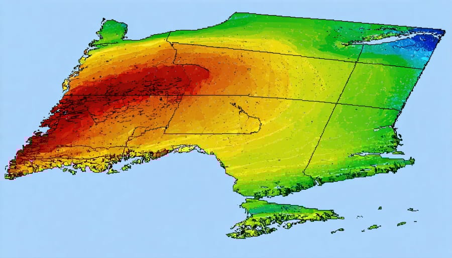
Ground Temperature Analysis
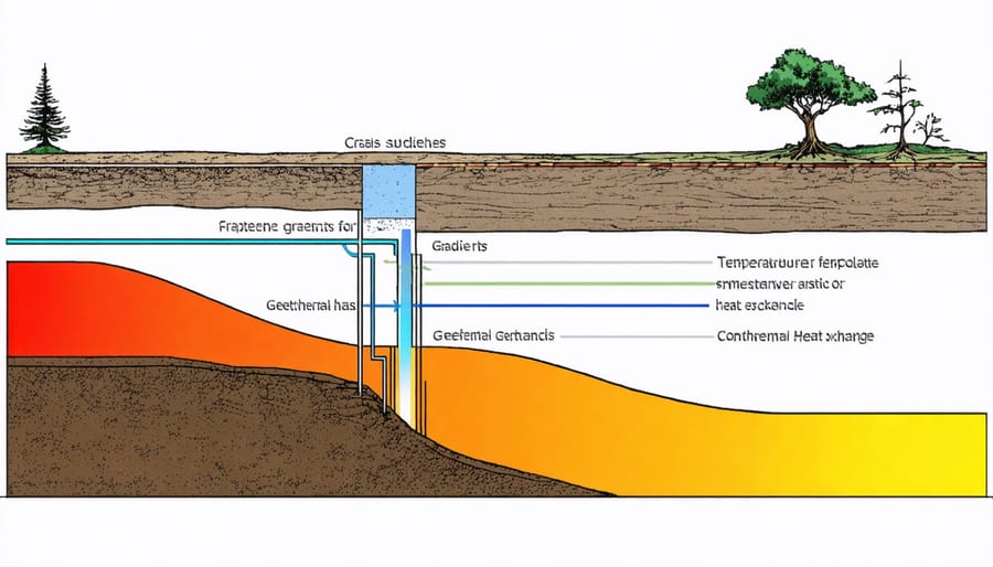
Ground temperature analysis is a critical step in evaluating geothermal energy potential for any site. Modern assessment tools combine sophisticated temperature mapping technology with data analytics to provide accurate subsurface thermal profiles. These tools typically include ground temperature sensors, thermal conductivity testing equipment, and specialized software for data interpretation.
The Ground Thermal Response Test (TRT) stands as the industry standard for site assessment, measuring the thermal conductivity and temperature distribution of soil layers up to 200 meters deep. This test typically runs for 48-72 hours, providing essential data for system design and capacity planning.
Advanced Geographic Information Systems (GIS) integrate multiple data layers, including geological surveys, groundwater conditions, and historical temperature records, offering comprehensive site evaluation. These systems help identify optimal locations for geothermal installations and predict long-term performance.
Distributed Temperature Sensing (DTS) technology uses fiber-optic cables to monitor ground temperatures in real-time across large areas. This continuous monitoring capability enables better system optimization and maintenance planning, resulting in improved operational efficiency.
For initial assessment, thermal imaging surveys can quickly identify areas of varying ground temperatures, helping to locate the most promising sites for detailed investigation. When combined with geological modeling software, these tools provide decision-makers with detailed feasibility reports and ROI projections, essential for project planning and investment decisions.
System Sizing Tools
Modern system sizing tools have revolutionized the process of determining optimal renewable energy system dimensions. Leading software solutions like RETScreen and System Advisor Model (SAM) provide comprehensive analysis capabilities for solar, wind, and geothermal installations. These tools incorporate local climate data, energy consumption patterns, and site-specific parameters to generate accurate system recommendations.
For solar installations, PVWatts Calculator offers precise estimates of energy production based on panel orientation, tilt angle, and local solar irradiance. Wind energy planners benefit from tools like WindFarmer and WindPRO, which analyze wind resource data and optimize turbine placement for maximum yield.
Geographic Information System (GIS) mapping tools have become invaluable for renewable energy planning, allowing users to assess site suitability, identify potential constraints, and visualize system layouts. These platforms integrate multiple data layers, including topography, land use, and grid infrastructure.
Financial modeling tools complement technical analysis by calculating return on investment, payback periods, and lifecycle costs. Energy professionals can leverage these tools to create detailed feasibility studies and project proposals that demonstrate both technical viability and economic benefits.
Many utilities and energy consultants now offer web-based assessment platforms that combine multiple analysis tools, making it easier for stakeholders to evaluate different renewable energy options and make informed decisions about system implementation.
In today’s rapidly evolving energy landscape, these renewable energy assessment tools serve as invaluable resources for organizations seeking to reduce energy costs and enhance sustainability. By leveraging these specialized tools for solar, wind, and hydroelectric power evaluation, decision-makers can make data-driven choices that align with both environmental goals and financial objectives. The comprehensive analysis capabilities enable stakeholders to accurately forecast energy production, evaluate investment potential, and optimize system designs before committing resources.
The integration of these tools into the planning process significantly reduces project risks while maximizing returns on renewable energy investments. As technology continues to advance and renewable energy becomes increasingly central to our power infrastructure, these assessment tools will play an even more crucial role in shaping the future of sustainable energy development. Organizations that embrace these resources position themselves at the forefront of the clean energy transition, ensuring long-term success in an increasingly sustainability-focused business environment.