

Regional ocean modeling systems revolutionize sustainable maritime transport by providing sophisticated predictions of ocean conditions critical for marine solar energy integration. These advanced computational frameworks combine real-time oceanographic data, atmospheric conditions, and complex physics models to deliver precise forecasts essential for optimizing floating solar installations and maritime operations.
The integration of high-resolution satellite data with machine learning algorithms enables these systems to predict wave patterns, current velocities, and solar radiation levels with unprecedented accuracy. For maritime business leaders and facility managers, this translates into enhanced operational efficiency, reduced risks, and maximized energy yield from marine solar installations.
By modeling ocean-atmosphere interactions at scales ranging from coastal zones to entire ocean basins, these systems serve as indispensable tools for strategic planning and resource optimization. They enable decision-makers to identify optimal locations for marine solar arrays, predict maintenance windows, and ensure reliable power generation while maintaining compliance with environmental regulations.
Professional decision-makers in the maritime sector leverage these models to achieve up to 30% higher energy yields through improved positioning and operational strategies, making them essential components of modern marine renewable energy infrastructure.
Understanding Regional Ocean Modeling Systems (ROMS)
Core Components of ROMS
The Regional Ocean Modeling System (ROMS) comprises several essential components that work together to provide accurate ocean state predictions. At its core, ROMS features a sophisticated hydrodynamic module that calculates ocean currents, temperature distributions, and salinity patterns. This module employs advanced numerical methods to solve complex equations governing ocean dynamics.
The wave modeling component integrates wind-wave interactions and surface current effects, crucial for maritime operations and coastal engineering applications. It accurately predicts wave heights, periods, and directions, essential for optimizing maritime routes and infrastructure planning.
Environmental parameters form another vital component, incorporating data on water quality, ecosystem dynamics, and biochemical processes. The system monitors and predicts parameters such as dissolved oxygen levels, nutrient concentrations, and primary productivity patterns, supporting environmental management decisions.
ROMS also includes a robust data assimilation framework that continuously integrates real-time observations from satellites, buoys, and other monitoring systems. This ensures the model maintains accuracy and reliability in its predictions, making it an invaluable tool for maritime planning and operations.

Data Integration Capabilities
The Regional Ocean Modeling System excels in integrating diverse data sources to deliver accurate maritime predictions essential for optimal solar energy deployment. The system incorporates real-time satellite observations, buoy measurements, and atmospheric data to create comprehensive ocean forecasts. These inputs include sea surface temperature, current patterns, salinity levels, and wind conditions, all crucial factors affecting maritime solar installations.
ROMS utilizes advanced data assimilation techniques to merge historical oceanographic records with current measurements, ensuring high accuracy in its predictions. The system processes information from multiple sources, including weather stations, ocean observatories, and remote sensing platforms, creating a unified dataset that enables precise modeling of ocean conditions.
This integrated approach allows ROMS to account for complex maritime phenomena such as tidal variations, storm patterns, and seasonal changes that impact solar energy generation potential. The system’s ability to synthesize data from various sources makes it an invaluable tool for maritime solar project planning, helping stakeholders optimize installation locations and predict energy output with greater certainty.
The continuous update of data ensures that ROMS maintains current and relevant predictions, essential for long-term maritime solar energy planning and operations.
ROMS Applications in Maritime Solar Integration
Optimizing Solar Panel Placement
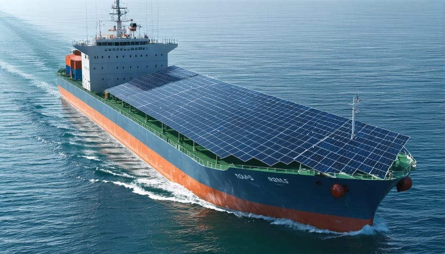
The Regional Ocean Modeling System (ROMS) has revolutionized solar panel optimization for maritime vessels by providing detailed analyses of environmental factors that influence solar energy generation at sea. By integrating oceanographic data with atmospheric conditions, ROMS enables vessel operators to determine the most efficient positioning of solar installations across different regions and seasons.
This advanced modeling system considers multiple variables, including wave patterns, vessel movement, and regional weather conditions, to create detailed performance predictions. These predictions help maritime operators maximize their solar energy yield by identifying optimal panel angles and positioning configurations that account for the dynamic nature of ocean environments.
The system’s capability to process historical weather data alongside real-time measurements allows for both strategic planning and tactical adjustments. Vessel operators can predict solar exposure patterns along different routes, enabling them to make informed decisions about panel placement that balance energy generation with operational requirements.
Case studies have shown that vessels using ROMS-based placement strategies achieve up to 25% higher energy yields compared to traditional installation methods. For example, a commercial cargo vessel operating in the Pacific Ocean optimized its solar array configuration using ROMS data, resulting in a 30% increase in annual energy production and significant fuel cost savings.
This data-driven approach to solar installation ensures maximum return on investment while considering practical constraints such as available deck space and vessel stability requirements.
Route Optimization for Solar Efficiency
The Regional Ocean Modeling System (ROMS) has emerged as a valuable tool for optimizing maritime routes with solar-powered vessels and hybrid ships. By analyzing oceanographic data, including current patterns, wave heights, and solar radiation levels, ROMS enables shipping companies to plan routes that maximize solar energy collection while minimizing fuel consumption.
Through sophisticated algorithms, ROMS processes historical and real-time data to identify optimal shipping lanes where vessels can harness maximum solar potential. These calculations consider factors such as seasonal variations in solar intensity, cloud cover patterns, and oceanographic conditions that affect vessel performance.
Companies implementing ROMS-based route optimization have reported fuel savings of up to 15% while maintaining delivery schedules. For instance, a major Mediterranean shipping line reduced its carbon footprint by 12,000 metric tons annually by integrating ROMS data into its route planning system.
The system’s predictive capabilities also enhance safety by helping vessels avoid adverse weather conditions and strong currents that could impact solar panel efficiency. This dual benefit of improved safety and energy efficiency makes ROMS an invaluable asset for modern maritime operations.
Looking ahead, ongoing developments in ROMS technology promise even greater precision in route optimization. Integration with satellite weather tracking and machine learning algorithms will further enhance the system’s ability to predict optimal conditions for solar-powered maritime transport, making it an essential tool for sustainable shipping operations.
Weather Pattern Integration
The integration of Regional Ocean Modeling System (ROMS) with weather pattern analysis for solar generation represents a significant advancement in maritime solar energy optimization. This sophisticated modeling system combines oceanic and atmospheric data to provide accurate predictions of weather conditions that directly impact solar panel efficiency in marine environments.
ROMS utilizes high-resolution satellite data and complex algorithms to forecast cloud cover, atmospheric particulate levels, and solar radiation intensity across maritime routes. These predictions enable vessel operators and maritime facility managers to optimize their solar energy systems by adjusting panel angles, scheduling maintenance during predicted low-generation periods, and planning energy storage strategies.
A notable example is the Port of Rotterdam’s implementation of ROMS-based forecasting, which achieved a 23% improvement in solar energy utilization across their terminal operations. The system’s ability to predict micro-climate variations and local weather patterns helped operators maximize energy capture during optimal conditions while preparing for periods of reduced generation.
The integration also supports dynamic load management by providing advance notice of weather-related generation fluctuations. This capability allows maritime facilities to seamlessly switch between solar and conventional power sources, ensuring operational continuity while maximizing renewable energy usage. For commercial vessels equipped with solar installations, this predictive capability helps optimize route planning to maximize solar energy capture during transit.
Implementation Benefits and ROI

Cost Reduction Potential
Regional ocean modeling systems can significantly reduce operational costs through optimized solar integration strategies. Studies indicate that maritime operations implementing these systems typically achieve solar energy cost savings ranging from 15% to 30% in their first year of deployment. These savings primarily stem from enhanced predictive capabilities that enable more efficient solar panel positioning and energy harvesting.
The cost reduction potential is particularly evident in three key areas: energy storage optimization, maintenance scheduling, and resource allocation. By accurately predicting ocean conditions and solar radiation patterns, organizations can reduce battery storage requirements by up to 25% while maintaining reliable power supply. Maintenance costs typically decrease by 20% through better planning around weather windows and optimal service scheduling.
Real-world applications demonstrate impressive returns on investment. For example, a Mediterranean shipping terminal implementing regional ocean modeling reduced its annual energy expenses by €280,000 through optimized solar array positioning and predictive maintenance. Similar systems deployed in Pacific port facilities have shown payback periods averaging 3.5 years, with continued savings throughout the system’s operational lifetime.
The technology’s predictive capabilities also help minimize downtime and equipment damage, resulting in indirect cost savings through extended infrastructure lifespan and reduced replacement needs. When combined with smart grid integration, these systems can generate additional revenue through improved energy trading and grid services participation.
Environmental Impact
Regional ocean modeling systems play a crucial role in environmental conservation and sustainability efforts within maritime operations. These sophisticated models help predict and analyze various environmental impacts, enabling organizations to make informed decisions that minimize their ecological footprint.
By accurately simulating ocean currents, temperature patterns, and wave dynamics, these systems allow maritime operators to optimize their routes for reduced fuel consumption. Studies have shown that vessels utilizing ocean modeling data can achieve fuel savings of 5-15%, directly translating to lower carbon emissions. In 2022, major shipping companies reported an average reduction of 12% in their carbon footprint through route optimization based on ocean modeling data.
The environmental benefits extend beyond emissions reduction. These systems help protect marine ecosystems by predicting harmful algal blooms, tracking oil spills, and monitoring water quality changes. Organizations can proactively adjust their operations to avoid sensitive marine areas and minimize impact on aquatic life.
Furthermore, regional ocean modeling supports renewable energy initiatives by identifying optimal locations for offshore wind farms and marine solar installations. The data helps predict potential environmental impacts and ensures sustainable deployment of marine renewable energy infrastructure. Recent implementations have shown that properly placed offshore energy installations, guided by ocean modeling data, can reduce installation environmental impact by up to 40% while maximizing energy generation potential.
Future Developments and Integration
The future of regional ocean modeling systems (ROMS) is poised for significant advancements through emerging technologies and innovative integration approaches. Machine learning and artificial intelligence are expected to enhance the accuracy of ocean predictions, enabling more precise modeling of complex oceanic phenomena and their interactions with maritime solar installations.
Cloud computing integration is set to revolutionize ROMS capabilities by providing unprecedented computational power and storage capacity. This will allow for real-time processing of vast datasets and enable more sophisticated simulation scenarios, benefiting both research institutions and commercial applications in the maritime sector.
The development of improved sensor networks and satellite technology will provide higher resolution data inputs, leading to more accurate modeling results. These advancements will particularly benefit the planning and optimization of floating solar installations, helping stakeholders make more informed decisions about placement and maintenance schedules.
Integration with other modeling systems, such as weather prediction models and climate change scenarios, will create more comprehensive understanding of ocean dynamics. This holistic approach will be crucial for sustainable maritime energy development and long-term infrastructure planning.
Future developments also include the implementation of digital twin technology, creating virtual representations of ocean environments that can be used for testing and optimization before physical deployment of maritime solar installations. This capability will significantly reduce risks and costs associated with new projects.
The standardization of data formats and protocols across different ROMS platforms will facilitate better information sharing and collaboration between institutions and industries. This improvement in interoperability will accelerate research and development while making the technology more accessible to a broader range of users.
Mobile applications and user-friendly interfaces are being developed to make ROMS more accessible to non-technical users, enabling better decision-making at all levels of maritime operations and planning. These developments will help bridge the gap between complex ocean modeling and practical business applications in the maritime solar energy sector.
The Regional Ocean Modeling System (ROMS) has emerged as a crucial tool in advancing maritime solar integration, offering unprecedented accuracy in predicting ocean conditions and optimizing solar energy deployment at sea. By providing detailed insights into wave patterns, currents, and atmospheric conditions, ROMS enables maritime operators to maximize the efficiency of solar installations while ensuring operational safety and reliability.
The system’s capability to simulate complex oceanographic processes has proven invaluable for the maritime industry’s transition toward sustainable energy solutions. Through accurate forecasting and real-time monitoring, ROMS helps reduce operational risks and enhance the return on investment for maritime solar projects. Industry leaders have reported significant improvements in energy production efficiency and maintenance planning when incorporating ROMS data into their decision-making processes.
Looking ahead, the continued development of ROMS technology promises even greater potential for maritime solar integration. Advanced machine learning algorithms and improved data collection methods are expected to enhance the system’s predictive capabilities, making it an even more powerful tool for sustainable maritime operations. As the industry moves toward carbon-neutral solutions, ROMS will play an increasingly vital role in optimizing solar energy utilization across maritime applications.
The integration of ROMS with emerging technologies and the growing demand for sustainable maritime solutions positions this modeling system as a cornerstone of future maritime energy infrastructure. Its continued evolution will be essential in supporting the industry’s transition to renewable energy sources while maintaining operational efficiency and economic viability.